Sashay
Sashay is a mobile phone application that leverages the fact that every fixed mobile phone cell tower transmits a unique ID that can be read within the phone’s software. As a user moves throughout an urban landscape this “cell ID” changes. Sashay keeps track of the temporal patterns, history, and adjacencies of these cell encounters to help it build a visualization of connected “places”.
More info coming Spring 2007
Technical Details
Sashay is written entirely using the Java J2ME library for mobile phones. It uses a small unmodified tool as part of the standard Place Lab install to enable access to the cell ID information. As tested the entire system operates on the Nokia 60 series platform – specifically the Nokia 6630.
Every three seconds the J2ME application queries the Place Lab tool to acquire the current cell ID. After each reading, two large internal data structures are updated followed by the visual display. The first data structure is a hashtable containing every cell ID encountered along with details for each cell such as the total number of visits, cumulative time spent in cell, and a time of day histogram for each cell visit. The other major data structure tracks every cell event. It contains information for the adjacency relationships between cells. For example, which cell we just came from, a list of all cells we have historically moved directly into from this cell, which cell are we most likely to move into, etc. The dataset can grow to be quite large and a special caching mechanism keeps only recent and active cells in memory. The remaining data is stored in the phone’s non-volatile memory. Each time Sashay is launched it reads in all previous data and locates the current cell ID. It is also capable of computing the personal, historical pattern of all visited cells from the current cell. The graph is directional so path of movement is captured not simply adjacency.
Visualizing the Experience
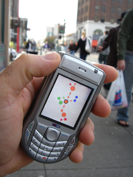
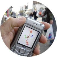
Sashay operates as more of a peripheral application or screen saver on your mobile phone similar to Jabberwocky. During everyday activity an individual can simply glance at Sashay to capture a sense of place and movement across a city. Each unique cell ID is represented by a small colored circle. Only a very small set of these cells are actual drawn at any given time. At the center of the visualization is the current cell which is highlighted. Extending downward is the link showing the previous cells that have been actually transited to arrive at the current cell. A link is drawn between each of these circles to emphasize the connections. Extending outward in all directions from the center cell are possible future links to cells that have been encountered in the past. The most common path taken out of the current cell is drawn directly atop the current cell. Recursing, each of those possible cells again calculates and renders its set of possible cells. This simple paradigm means that when a user takes a different, or in this case literally “the path less traveled”, the visualization will capture such movement dramatically as the path moves off of the center common line and onto a side forked path.
Each circle is also scaled in size such that cells that are visited frequently or where a lot of time is spent are larger than cells that are transited quickly. Finally, cells are colored based on the most common time of day when they are visited: early morning (orange), afternoon (yellow), late afternoon (green), and evening (blue). The overall visualization expresses your personal patterns across the city without interpreting its meaning. It reflects a notion of what type of city person you are. Do you stay mostly within a small range of cells? Do you move between only three main parts of a city? Do you quickly move across a city? What does a road trip to Las Vegas look like? A night out? A dog walk? A weekday morning? A weekend afternoon?
Recall that we are not interested in using these signals, their strengths, and the fixed locations of the cell towers to extrapolate an actual location. In fact we explicitly avoid labeling any of the cells. The value of Sashay is not in helping you navigate or realize that you are in downtown Austin or at a park in Boston. It is meant to explicitly remove such labeling and leave only an intentionally skeletal sketch of a person’s personal patterns across a city, leaving the individual to wonder and construct their own narrative and meaning. The temptation to build a labeled map is so compelling to many researchers that we are reiterating and advocating the extraordinary value of keeping such visualizations free from literal place labelings.
It is important to remember that we are interested in exploring the notion of wandering across simply the series of everyday cell IDs as itself an invisible landscape. This simple inversion of the map-signal paradigm gives rise to a series of remarkably interesting differences. Recall that two “places” are connected if their cell IDs are simply encountered in sequence. Using this paradigm creates many new “connected” places. For example, New York’s JFK Airport is now directly adjacent to London’s Heathrow airport since you move seamlessly between the two cell IDs when you fly between them. Similarly, there are multiple connections between places. Driving between Oakland and San Francisco over the Bay Bridge creates a series of small connected dots as you quickly transit a series of cell IDs. However, taking the underground subway, we find Oakland and San Francisco directly adjacent to each other in the visualization since the cell IDs are seen in sequence.